


An extreme amount of rain will fall through the end of the week that could lead to generational flooding in Arkansas, Missouri, Tennessee and Mississippi, according to the National Weather Service.
Level 3 of 4 risks of flooding rainfall encompass parts of the Mississippi and Ohio valleys on Wednesday, Friday and Saturday, according to the Weather Prediction Center.
A rare level 4 of 4 high risk of flooding rainfall is in place Thursday from extreme northeastern Arkansas through far western Kentucky. Its hard to overstate just how significant these high risk flooding events are. They are issued on fewer than 4% of days per year on average, but are responsible for more than 80% of all flood-related damage and 36% of all flood-related deaths, WPC research shows.
This is an increasingly significant setup with the potential for high impacts and life-threatening flash flooding spanning the course of several days, the center warned.
After rain begins Wednesday, each day that follows will see the threat of flooding ramp up. The ground will get increasingly soaked until it becomes unable to absorb more and any rainfall after that point will set off dangerous flash flooding.
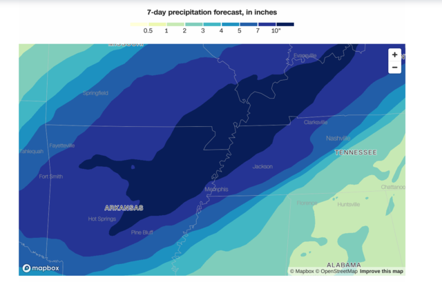
Storms will work over the same areas repeatedly and could drop 2 to 6 inches of rain each day especially from Arkansas to Indiana.
By Saturday, areas caught repeatedly under the heaviest storms could end up with more than 15 inches of rain. The corridor where Arkansas, Missouri, Illinois, Kentucky and Tennessee meet is the most likely place for these extreme totals.
If we get anywhere near these amounts, a historic flash flooding event is likely, the National Weather Service in Paducah, Kentucky, warned.
An entire springs worth of rain could fall in just four days in the hardest-hit locations. Paducah, for example, averages about 14.5 inches of rain from March to May.

 Reply With Quote


Bookmarks