-
 Incoming
New timing: Two rounds of severe storms possible today
System expected to bring storms, some severe, Sunday
WYFF 4 Updated: 10:27 AM EDT Apr 14, 2019
GREENVILLE, S.C. —
New data suggests severe weather is possible in two rounds today. WYFF News 4 meteorologist Chris Justus says the latest data indicates the risk is high for damaging strong winds, hail and even isolated tornadoes with the storms. Chris said the latest timing for the severe weather is between 12 p.m. and 3 p.m. for the first round. Chris said the second round could move through between 4pm and 8pm.
Model data that came in late Saturday evening continues to indicate severe weather is likely Sunday.
Confidence is increasing that severe weather will be likely across the western Carolinas and in northeast Georgia on Sunday afternoon.
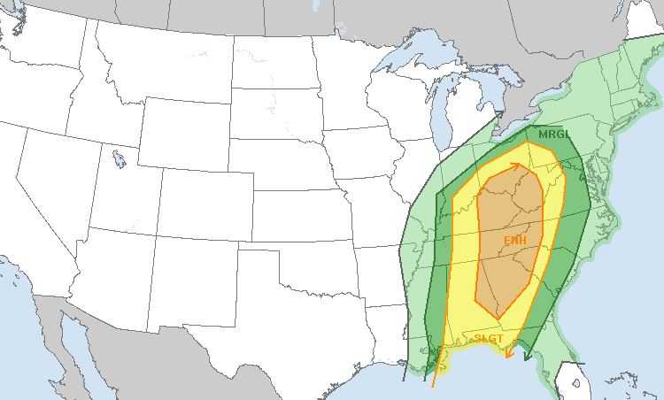
WYFF News 4 meteorologist Chris Justus says the latest data indicates the risk is high for damaging strong winds, hail and even isolated tornadoes with the storms. Chris said the latest timing for the severe weather is between 12 p.m. and 6 p.m.
Our area remains in the “enhanced risk” for severe weather. Chris said it is very rare to see the Storm Prediction Center out of Oklahoma issue an enhanced risk for severe weather for our area.
Warm, humid air is spreading north into the area as a strong front and an accompanying low-pressure system track toward the east.
“There is tremendous amount of velocity and power in the atmosphere with this system and a lot of wind shear and a lot of instability at the surface, because it’s going to be very warm,” Chris said.
All of the western Carolinas and northeast Georgia are in the enhanced risk area.
On Sunday, scattered thunderstorms will begin around midday. The thunderstorms will continue into the evening before clearing out overnight.
Thunderstorms are likely at the Masters Tournament in Augusta, Georgia, on Sunday.
Monday is expected to be sunny.
 Posting Permissions
- You may not post new threads
- You may not post replies
- You may not post attachments
- You may not edit your posts
-
Forum Rules


 Reply With Quote
Bookmarks