
 Senior Member
Last edited by XHailGC; 09-29-2016 at 09:18 PM.
Senior Member
Can you imagine the cost today if a Cat 4 hit SC compared to the damages in 1954. Shit!
"We have become so open minded that our brains have fallen out"
 Senior Member
Looks very similar in track.
 Resident IT Guy
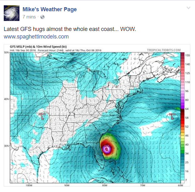
Hopefully it will follow the projected path of these models:
http://www.tropicaltidbits.com/storm...efs_latest.png
Senior Member
 Senior Member
I'm leaving for Negril on Thursday. Hopefully that bastard doesn't completely destroyed jamaica.
So then, just as you received Christ Jesus as Lord, continue to live in him, rooted and built up in him, strengthened in the faith as you were taught, and overflowing with thankfulness. Colossians 2:67Originally Posted by squatty

Senior Member
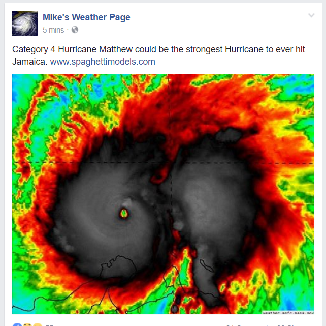
Only a category 4 right now.
 Senior Member
Only?
I don't want to see a cat 4
 Senior Member
This one is a nasty bitch. Going to be interesting to see what happens by the end of the weekend in regards to track. Amazing how fast this thing intensified in such a short period of time
"Sweet, hard to beat cold beer and deer drowing."
Senior Member
Latest model. Not looking good.
 Senior Member
That doesn't look good
 MP7 @ Home
Not in the slightest...
Sent via TapaTalk on S7 Edge.
 Old, But Not Retired
I was a boy in Horry County (Loris) when Hazel hit. I still remember how the winds howled and shook the house! It tore Cherry Grove Beach up!!
That the Tiger's roar may echo.....
 Senior Member
They're expecting it be a Cat 5 by the time it makes it to the Carolina's, if it doesn't make landfall before then.
 Senior Member
The best case scenario seems to be it strafes the coast. I pray I am wrong and it turns into a fish storm. Things are about to get ugly fellas.
Sent from my SM-G920P using Tapatalk
 Schmoderator
No crap, I'm getting married in Ochos Rios the first of December..
Natural Born Killer Prostaff - Killing Tomorrow's Trophies Today...
TFC -"Be tough or get tough"
Conservation Permit Holder #5213
 No Loaf'n
Senior Member
No Loaf'n
Senior Member
Cat 5 160 MPH 11:00 update. damn
 Senior Member
D'yer Maker bout to be fooked.
Senior Member
184 MPH wind gusts
Tropical Weather Discussion for North America, Central America
Gulf of Mexico, Caribbean Sea, northern sections of South
America, and Atlantic Ocean to the African coast from the
Equator to 32N. The following information is based on satellite
imagery, weather observations, radar and meteorological analysis.
Based on 1800 UTC surface analysis and satellite imagery through
2315 UTC.
...SPECIAL FEATURES...
Hurricane Matthew is centered near 13.5N 72.0W at 01/0000 UTC or
about 70 nm NNW of Punta Gallinas Colombia and about 380 nm SE of
Kingston Jamaica moving WSW at 8 kt. Estimated minimum central
pressure is 945 mb. Maximum sustained wind speed is 130 kt with
gusts to 160 kt. Scattered to numerous strong convection is from
12N-15N between 68W-73W. Scattered moderate and isolated strong
convection is elsewhere from 11N-16N between 67W-74W. See latest
NHC Intermediate Public Advisory under AWIPS/WMO headers
MIATCPAT4/WTNT34 KNHC and the full Forecast/Advisory under AWIPS/
WMO headers MIATCMAT4/WTNT24 KNHC for more details.
Last edited by XHailGC; 09-30-2016 at 10:09 PM.
 Posting Permissions


 Reply With Quote


Bookmarks